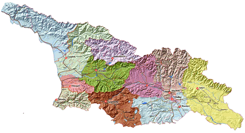
capital and regions
Administrative-Territorial Division
{nomultithumb}
Georgian territorial system includes three levels of division:
- The upper level - includes 9 Regions, 2 Autonomous Republics and capital Tbilisi;
- The middle level - 73 District and the 6 cities which are not under the subordination of the district;
- The lower level - village, community, small town, town;
Georgia is divided into 9 regions, 2 autonomous republics and 1 city:
Administrative-teritorial division Interactive map
| Autonomous Republic / Region / City | Area | Population | Adm.Center |
| Abkhazia (Autonomous Republic) | 8,640 km² | 525,000 | Sokhumi |
| Ajara (Autonomous Republic) | 2,900 km² | 376,000 | Batumi |
| Guria (Region) | 2,003 km² | 141,000 | Ozurgeti |
| Imereti (Region) | 6,552 km² | 703,000 | Kutaisi |
| Kakheti (Region) | 11,310 km² | 407,000 | Telavi |
| Kvemo Kartli (Region) | 6,528 km² | 381,000 | Rustavi |
| Mtskheta-Mtianeti (Region) | 6,785 km² | 125,000 | Mtskheta |
| Racha-Lechkhumi and Kvemo Svaneti (Region) | 4,954 km² | 51,000 | Ambrolauri |
| Samegrelo and Zemo Svaneti (Region) | 7,441 km² | 382,000 | Zugdidi |
| Samtskhe-Javakheti (Region) | 6,413 km² | 208,000 | Akhaltsikhe |
| Shida Kartli (Region) | 6,200 km² | 314,000 | Gori |
| Tbilisi (City) | 140 km² | 1,106,000 | Tbilisi |
Tbilisi
The capital of GeorgiaTbilisi stands on the banks of the River Mtkvari, in a valley surrounded by hills. The name for the city derives from the word tbili (warm). It is best seen from the top of Mount Mtatsminda.


