Imereti
 The region of Imereti is situated along the middle and upper end of the Rioni river. The main city of the region is Kutaisi.
Geography
Imereti is divided into Zemo (upper) and Kvemo (lower) Imereti. It borders the Likhi Mountain Range to the east, Tskhenistskali River to the west, the Caucasus Mountains to the north and Meskheti or Persati Mountains to the south.
The lowlands of Imereti are mostly covered with Colchis low brush, forests, oaks, groves, and meadows. The mountainous parts of Imereti are mainly Colchis deciduous forests.
The forests of Imereti are rich with animals and birds. Zekari, Ajameti and Kharagauli forests are populated with bears, wolves, martens, foxes, jackals, badgers, deer, rabbits, squirrels and bobcats. Some of the most common birds are: jay, cuckoo, nightingale, woodcock, hoopoe as well as some rare birds.
HISTORY AND ARCHEOLOGY
During the 13th century BC a big union of tribes lived on the territory of Imereti. Soon after an early Georgian state was created, called "Colcha". Its name was first mentioned in oriental sources in the 12th and 11th centuries BC. After the fall of Colcha, the powerful and well-known Colchis Kingdom (of Kolkheti) was established in the 7-6th centuries BC.
This was the legendary kingdom where the Argonauts were said to have traveled to find the Golden Fleece. Within the legend exists the historic fact that gold found in the Colchis region was especially well-known, and served as the basis for calling Colchis the country with an abundance of gold. During 6-4th centuries BC the Colchis Kingdom used to produce its own silver money, called the Kolkhuri Tetri.
During 6-3rd centuries BC the Colchis Kingdom fell under the control of another Georgian Kingdom, Iberia. During the 1st century AD a new state unit, the Egrisi Kingdom was created in the territory of Colchis, which soon fell under the influence of the Roman Empire. Greeks and Persians fought over Egrisi, and then at the beginning of the 7th century, Egrisi was attacked and destroyed by the Arab ruler - Murvan the Deaf.
Afterwards Imereti was still the center of Georgian life. During the 8th century Kutaisi became the capital of western Georgia and the capital for all of Georgia in the 10-12th centuries.
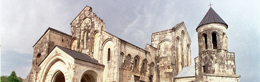
It was during this period that Imereti had a renaissance. Unique masterpieces of Georgian architecture were created at this time – Bagrati Cathedral and Gelati Monastery Complex, both of which are protected by UNESCO. During the 15th century, after the fall of the Georgian feudal monarchy, Imereti became a separate feudal kingdom – the Imereti Kingdom. The king was the supreme ruler, who had his Darbazi (Council) serve as the state council.
Kutaisi has risen to power and been destroyed many times due to its wealth and strategic territorial location. For centuries Kutaisi has been a center of culture and education. During the Soviet era Kutaisi was one of the biggest industrial cities of the country. At the moment it is the second biggest city in Georgia.
A number of trade roads, including the Silk Road, crossed this area, supporting the development of culture and trade. Findings from archeological excavations show that the first known human being in Imereti lived during the lower Paleolithic period.
The most interesting is the town of Vani, which is known to have existed as early as the 8th century BC. It was one of the most important towns of the Colchis Kingdom. At present there is a museum and the ruins of the ancient town. The ruins are located on twelve hectares, and presently only 1/3 of the area has been studied
CULTURE AND TRADITIONS
Imereti has always been known for its highly developed spiritual and family culture, believed to be influenced by the Colchis. Imereti developed viticulture, cattle-breeding, poultry-farming, bee-keeping, production of dairy products and gardening. Some of the most important agricultural sectors were viticulture, the cultivation of corn crops, and orchards.
This area of Georgia has some unique wine varieties and there is evidence that wine production here dates back to ancient times. Proof of their dedication to the craft of wine making can be seen in the ancient wine jars, grape presses, winery rules and traditions of the Georgian table in Imereti.
The villages of Imereti are colorful and have a special charm. Feasting and fun are an integral part of life for the people of Imereti, while singing is an essential element of the banquet table. The tradition of modern songs with guitar accompaniment in Georgia originated in Imereti. Even now, folk polyphonic, lyric and joyful songs are performed during festivities in Imereti. A number of folk traditions and rituals have been preserved in Imereti.
Racha
Geography
 Racha-Lechkhumi is a region in northwestern Georgia. It is the most sparsely populated region in the country. Ambrolauri is the administrative centre of the region.
The region boasts a diverse landscape of mountain forests and meadows. The low lands are covered with forests of beech trees at high altitudes, along with pine and spruce trees.
History
The remnants of the first human beings living in the region can be traced back to the Neolith era. Archeologists discovered "Tsageri Treasures" in Lechkhumi, dating back to the 10-9th centuries BC.
Discovered in clay pots, the treasure included a statue of a rider with a bronze helmet, copper pillars, work instruments and − especially interesting − a Colchian axe decorated with an engraved snake.
Historical sources first mention this region in the 6th century BC. Racha-Lechkhumi was part of the early Georgian Kingdom, the Colchis Kingdom, which was created in the 7-6th centuries BC and was known to be wealthy and strong; examples of money minted in the kingdom – the Colchis Tetri – were discovered in Oni.
After the Colchis Kingdom fell apart during the 1st century AD, the territory of modern Racha-Lechkhumi was part of several successive kingdoms until the county of Racha was created in the 10th century, as part of the United Kingdom of Georgia.
Culture and traditions
Cultural monuments and strong traditions have been passed down through the generations in Racha- Lechkhumi. Its people are known for their dedication to work, love for wine, and ability to sing. They still maintain ancient traditions of vineyards and winemaking, just as they were described in ancient Greek and Roman writing.
During the 19th century, wine bottled in Racha was presented at famous European exhibitions and wine bottlers won prizes which can still be found in local museums. As many as 60 local species of grape vines were cultivated here, including Alexandrouli, Usakhelouri, Mujuretuli, Tsolikouri, Tetra and Ojaleshi. The most popular is Khvanchkara wine, made from grapes that can only grow on the rich lands of Khvanchkara village.
The population of Racha-Lechkhumi is known for viticulture, bee-keeping, production of dairy products, cattle-breeding and horticulture, as well as carpentry and singing. Racha, like most of Georgia, is known for its hospitality.
Carpenters of Racha are famous throughout Georgia. One of the biggest contributions they have made to Georgian art is the "Sakvartskhuli", the chair used by the head of the family. It had three legs and a semi-circular back. Traditionally the back of the chair is decorated with symbolic engravings.
In the regions outside of the capital, tourists can watch – and even participate – in the process of making traditional crafts. Racha is known for its wood craftsmanship.
Svaneti
Svaneti, one of the most ancient historical provinces of Georgia, is located on the southern slopes of the Caucasus mountain range, on the territory running between the Enguri and Tskhenistskali Rivers.
Surrounded by the gigantic, white-capped peaks of the Caucasus, Svaneti is one of the most remarkable regions of Georgia with a rich history and picturesque natural beauty.
GEOGRAPHY
 Svaneti is divided into two parts, Upper Svaneti and Lower Svaneti, separated by the Svaneti Mountain Range.
The first road accessible by car from Zugdidi to Svaneti was built in 1934. Prior to that, roads to Svaneti were only passable by carriage, horse, or foot. Svaneti is 500 kilometers away from Tbilisi and the trip takes around 8-10 hours.
Major villages of Upper Sanity are Mestia, Etseri, Becho, Kala, Latali, Lakhamula, Lenjeri, Mujhal-mulakhi, Ushguli, Fari, Tskhumari, Chuberi, and Khaishi.
Svaneti boasts several 4000-5000 meter high peaks such as: Shkhara (5068 m), Rustaveli (4960 m), Gestola (4859 m), Tetnuldi (4851 m), Ushba (4700 m) and Ailama (4546 m).
CLIMATE
At 2000 meters above sea level, the climate of Upper Svaneti is humid and cold. The average annual temperature is 5.70C with temperatures in January averaging -6.40C and 16.40C in July. In the highest altitude areas of Upper Svaneti the climate is humid, characterized by an absence of a real summer.
CULTURE AND TRADITIONS
The culture of Svaneti has been developing since the third century - a period in which scholars believe mining and metal production was introduced to the region. It is assumed that the first inhabitants of this mountainous Georgian region came from the lowlands of Chorokhi Gorge, a place known for being rich in metal ores.
In early centuries Svaneti was part of the Colchis Kingdom and later became part of the Egrisi Kingdom. Svaneti periodically gained independence and had its own ruler and tribal councils. It is believed that Christianity was brought to Svaneti around 523–530 AD. Svaneti has never been destroyed by enemy forces.
Therefore, little or no outside influences have been incorporated into the life of the Svan population – which dates back to antiquity. Greek historian and ethnographer Strabo provided the following information regarding Svans: “They are noteworthy for their courage and power, they reign over almost everything around them and control the peaks of the Caucasus.”
Building and developing a society in such rough terrain required hard work. Settlements were started from large family farms. Brotherhoods were created as big families divided, which created territorial communities within the river gorges. This patrimonial tribal structure has been practiced for centuries in Svaneti.
Starting from ancient times, Svans developed cattle breeding and plant cultivation, and their religious beliefs and traditions were tied to the fields. Ancient Svans are known for their tower settlements, unique species of wheat, and their own school for sacred wall painting.
Svans created musical instruments unique to the region and also developed a tradition of woodcarving, examples of which can still be found today in some homes and churches. Carpenters still make incredible furniture using the same traditional decorative ornaments.
The myth of the Greek Argonauts’ voyage to Colchis is thought to be connected to the gold of Svaneti, which was brought to the region by the rivers’ currents. At that time Svaneti was part of the Colchis Kingdom and was the only territory that supplied the Colchis Kingdom and King Ayet with gold.
Svans used sheep wool to capture gold - the wool was fixed to a board that was placed into water, wool side up. Once removed from the water and dried, the gold would fall from the dry wool. This way of finding gold, and the existence of gold in Georgian rivers, was known to ancient Greek and Roman writers.
The traditions and habits of Svans are just as fierce as the region’s nature and climate. Svans have great respect for rituals, which often feature deities protecting cattle and people, and granting fertility.
Svans sing polyphonic songs about their ancient ancestors, hunters, gold miners, cattle breeders and land workers. Svans also have dances that are unique to the region.
Hat is an integral accessory of Svani clothing. The expressions “May God Protect You” and “May the Cross Protect You” have direct meaning here – the threads over the wearer’s head are sewn in a cross pattern.
Samtskhe-Javakheti
 Samtskhe-Javakheti is a historic southern region of Georgia which includes present-day Akhaltsikhe, Adigeni and some districts of Aspindza. It is edged by the Arsiani Mountains to the west and shares a border with Adjara. To the north it is edged by the Persati Mountains and has borders with Guria and Imereti. Its southern edge runs along the Georgian border with Turkey and Armenia. The historical Georgian territories of Erusheti and Shavsheti are now parts of Turkey.
Javakheti includes the towns of Akhalkalaki and Ninotsminda and part of the Aspindza district as well. Samtskhe and Javakheti are separated by the River Jobiskhevi (the right tributary of the Mtkvari River).
GEOGRAPHY
Samtskhe-Javakheti is a mountainous region, broken by ravines, springs, and lakes, as well as large and fast moving rivers. There are very few large flatlands in Samtskhe and the landscape is complex, composed of flat terraces, hills and volcanic mountains. The main rivers of Samtskhe are the Chorokhi and the Mtkvari.
The landscape of Javakheti is mainly composed of corrugated plains and is characterized by numerous hills, knolls and river canyons. There are many springs, small and big rivers, and freshwater lakes. The biggest lakes include the Pharavani, Khanchali, Sagamo, Madatapha, Bugdasheni and Tsunda.
 Rare natural landmark located in the region of Samtskhe-Javakheti is the Petrified Forest. It dates back to the Tertiary Era when the surroundings were covered with red-hot lava streams and downpour rains mixed with volcanic ashes from the nearby active volcanoes. This created a thick layer of volcanic rocks which covered the forested hills. One can still encounter petrified tree branches and fossilized lumps of wooden logs. The petrified plants include tropical and subtropical species. The absolute age of Goderdzi Reserve may be 12-15 million years old.
It is noteworthy that researchers have encountered the branch of a huge vine tree, with a diameter of over 30 cm. This discovery justified the assumption that the current territory of Georgia hosted both small and giant vines as far back as 15 million years ago.
HISTORY
Samtskhe-Javakheti is one of the oldest inhabited regions of Georgia. It boasts multiple archeological sites, although a lot of historical data about the land is still to be traced. Artifacts found during archeological diggings indicate that Samtskhe-Javakheti was settled during the Bronze Age.
Samtskhe-Javakheti was a part of historical Meskheti. The strategic location of Meskheti was favorable for cultural and economic development in the region.
Samtshke-Javakheti’s location at the crossroads of three civilizations contributed to intense development of relations between the ancient cultures of Georgia, Asia Minor, and the Middle East.
Historical Meskheti, which included Samtskhe-Javakheti, shared a border with Greece to the south and had an important role in the Iran-Byzantine wars of the 1st-5th cc., in which Iran was victorious.
The Iranians were ousted by the Byzantine Empire in 626 A.D.
Starting from the 9th century, the Byzantines and Turks undertook numerous attempts to exercise their political influence over Samtskhe, some of which were successful.
In the 12th century David IV the Builder liberated Meskheti, including Samtshe-Javakheti. In 1124-1213, during the reign of Queen Tamar, it became the site of several military actions, though cultural life continued to flourish.
Mongols appeared in Georgia by the end of the 13th century and eventually conquered Samtskhe-Javakheti along with the rest of Georgia.
By the end of the 16th century Samtskhe-Javakheti was once again conquered by the Turks. Samtskhe-Javakheti was part of Turkey until it was returned to Georgia after the Russo-Turkish War of 1828-29.